In early February, I joined over five hundred water industry personnel convening in Nashville, Tennessee for the 2019 Esri Water GIS Conference. Over the course of the three-day event, Esri representatives, solutions providers in the Esri partner network, and utility clients showcased the role of geographic information system (GIS)-based technology in enabling advanced asset management, enhanced operational efficiency, network intelligence, and digital transformation in the U.S. municipal water and wastewater sectors.
This conference raised important questions about:
-The role of GIS in the adoption of digital water technologies
-Vendor strategies in an evolving municipal water landscape
-The significance of a holistic view of water management for the utility of the future
Key takeaways from the conference include:
“Parallel GIS and SCADA market trends will structure and elevate competition within the U.S. digital water space, shaping R&D spend, M&A, and partnership activity moving forward.
Exhibit: Platform Convergence for Municipal Utilities
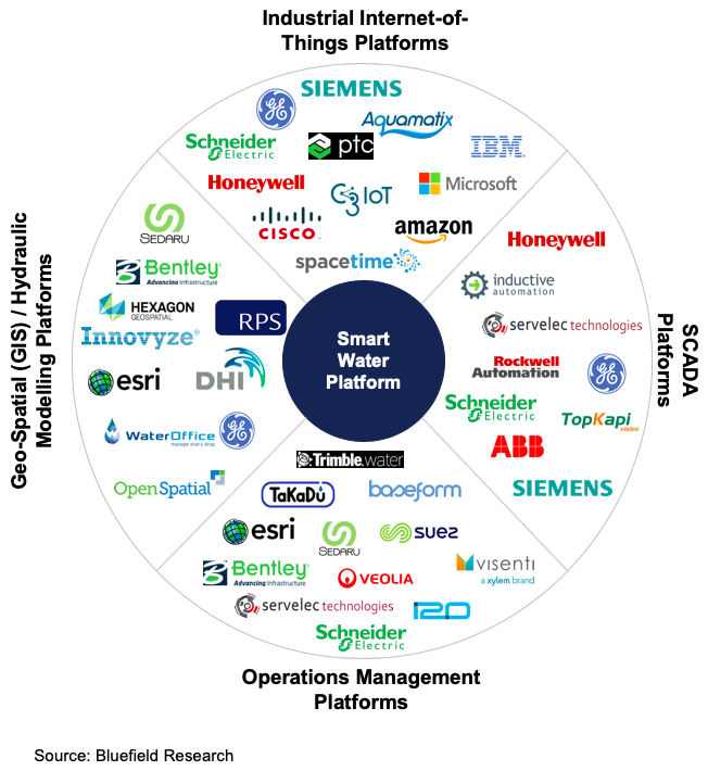
- Is the future of U.S. digital water vertical or linear? The SCADA market has traditionally focused on vertical assets– treatment plants and pump stations– but falling prices for monitoring and control instrumentation is enabling SCADA systems’ deployment further outward into utilities’ linear distribution and collection networks. Esri’s new ArcGIS Indoors and Utility Network solutions, meanwhile, reflect a strategic effort to bring the firm’s linear asset-centric GIS tools inside utilities’ vertical assets. These parallel trends will structure and elevate competition within the U.S. digital water space, shaping R&D spend, M&A, and partnership activity moving forward.
- The utility fieldworker plays a central role in achieving digital transformation. Esri and its partners, like Trimble, Cityworks, and Lucity, showcased numerous mobile and back-office tools for planning and executing field workflows. Bluefield estimates that labor costs will account for US$258 billion (or 28%) of water and wastewater utilities’ projected US$872 billion in total operating expenditures over the next decade, and fieldworkers can constitute as much as 70% to 80% of utility workforces. Thus, optimizing workorder planning and fieldwork processes via digital solutions can generate significant savings in labor time and costs for cash-strapped municipal utilities. Meanwhile, digitizing fieldworker knowledge can help utilities to cope with high retirement rates and staff training costs as the water industry confronts an aging workforce.
GIS, SCADA, and advanced asset management continue to shape the digital water landscape. Bluefield will be here along the way to track key trends, market shifts, and company strategies through our Digital Water insight service.